
At the Geospatial Summit on May 4-5, 2021, The National Geodetic Survey (NGS) provided an updated timeline for completing State Plane Coordinate System 2022 (SPCS2022) designs. Additional information was provided to stakeholders in a June 4, 2021, email from Michael Dennis, NGS’s SPCS2022 Coordinator.
NGS uses the term SPCS2022 to refer to up to three separate layers for each state: a statewide single-zone layer, and one or two multi-zone layers which could include a “traditional” SPCS layer (similar to Wisconsin’s three-zone SPCS of 1983) as well as a multi-zone LDP or Low Distortion Projection (similar to WISCRS). However, NGS rules only allow for a single statewide multi-zone layer.
Previous SCO news articles (such as this one) give details on the efforts of the Wisconsin Spatial Reference System 2022 Task Force (WSRS2022) to define SPCS2022 layers for Wisconsin. Wisconsin will have two SPCS2022 layers: a statewide single-zone layer and a statewide multi-zone layer. In early 2020, WSRS2022 asked NGS to design the single-zone layer and proposed a multi-zone LDP layer modeled after WISCRS. NGS approved the LDP in March, 2020. A design for the LDP layer, known as WIGGS for Wisconsin Grid-Ground System, with all needed zones and parameters, was submitted to NGS in September, 2020.
How Does Wisconsin Compare?
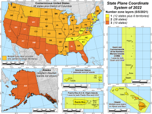
During his Geospatial Summit presentation, Dennis offered some maps and statistics on SPCS2022 zones and layers for the whole US. A total of 18 states and territories will have only a single statewide layer, 28 states (including Wisconsin) will have two layers, and 10 states will have three layers. (See Map 1)
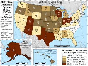
NGS will need to design 159 zones, including 54 statewide zones. Stakeholders (like WSRS2022) proposed a total of 810 zones in 28 states. WIGGS, like WISCRS, has 59 zones. Ohio’s LDP has the largest number of zones at 88.
Map 2 shows the total number of SPCS2022 zones in each state. Wisconsin’s total of 60 equals the 59 zones of WIGGS plus the statewide single-zone layer.
Timeline
Dennis’s email of June 4, 2021, addresses the SPCS2022 timeline. Some important notes:
- The review and design process has been slightly delayed, but the SPCS2022 project is still on schedule.
- Based on initial reviews, it appears that a large majority of states submitted designs that have no issues (or only very minor ones).
- NGS expects that official approvals will start going out within the next few months. Once that process begins, it should progress quickly for most states.
- Submitted designs for a few states have been approved, but most have not. (In Wisconsin, our LDP was approved in March, 2020, but we have not heard back “officially” on the design proposal submitted in September, 2020.)
- Preliminary partial NGS designs are now done for nearly all states, but complete preliminary parameters have been determined in only a few states.
- NGS expects to have all complete preliminary designs done by the end of this calendar year or early next year. At that time, the preliminary designs will be provided to all states for review.
- Once the stakeholder review of preliminary designs is complete, a set of final, complete parameters will be publicly distributed The target for distribution of final design is mid-2022.
Dennis also notes that since SPCS2022 is a fairly small part of the NSRS Modernization effort, it is possible that resources could be reallocated in a way that delays the SPCS2022 project.
For more information on SPCS2022, WIGGS and the NSRS Modernization effort see the WSRS2022 webpage.