
Since 1975, the State Cartographer’s Office has researched, stored, and provided access to geodetic control information for the Wisconsin surveying community. To ensure this information is available to the widest possible audience in a standards-compliant format, in 2004 the SCO submitted a proposal for a Federal Geographic Data Committee Cooperative Agreement Program (CAP) grant entitled “Establishing Framework Data Services using the OpenGIS Web Feature Service.”
The goal of this grant was to establish an Open GIS Consortium (OGC) Web Feature Service (WFS) to provide access to Wisconsin geodetic control point information. This would enable a comprehensive view of geodetic control information through a single web service hosted by the SCO.
A Web Feature Service (WFS) is an interface allowing requests for spatial data across the internet. The WFS is able to receive data requests from users and respond with spatial data in the form of Geographic Markup Language (GML). A number of software programs allow users to create and author WFS services, but our project focused on Mapserver, an open source development environment.
As part of the grant, we needed to not only author the WFS, but also to make sure the output GML would meet emerging FGDC Geodetic Control Data Content Standards. To meet these standards, we had to create a method to “transform” the GML as it was produced by the Mapserver WFS service. By transforming the GML, we are able to keep the geodetic control stored locally in our own format, but still provide the data to users or other applications in a neutral anticipated format.
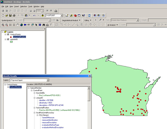
The geodetic control WFS in ArcMap.
This research extends our existing work of demonstrating the utility of Web Map Service (WMS) interfaces for publishing views of geographic information in a neutral, interoperable way for access by a wide variety of potential users. It also supports our educational, cataloging, and clearinghouse efforts, as well as foreshadows for our user community the next generation of internet-based real-time publishing of geographic data and map information through web services.
The results of the grant are fully described on the WISCLINC website, along with links to a WFS-compliant map service that can be accessed by anyone with an internet connection.