
On February 12th, the WI Department of Commerce started notifying 14 counties in southern Wisconsin that they will receive a total of approximately $3 million for LiDAR data acquisitions in 2010.
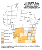
Counties offered the LiDAR funds include: Vernon, Juneau, Racine, Kenosha, Milwaukee, Monroe, Dane, Iowa, Lafayette, Fond du Lac, Richland, Adams, and Green. In addition, funding was offered to Crawford County to acquire LiDAR data along the Kickapoo Valley stream corridor. (See map at right)
Announced in November 2009, the Department of Commerce offered the grants through their Community Development Block Grant Emergency Assistance Program (CDBG-EAP). A total of 31 counties were eligible to apply for the funds ultimately aimed at improving floodplain mapping in southern Wisconsin. Eligibility for the program was determined by the 2008 federal disaster declarations for severe storms, tornadoes, and flooding.
Once the funds are formally accepted by the counties, work will begin on developing contracts with the data providers. The hope is to get the data acquisitions scheduled as soon as possible so the work can take place in conjunction with the Wisconsin Regional Orthophotography Consortium flights already scheduled for the spring of 2010.
The Department of Commerce received just over $6 million in applications from 20 counties. $1.5 million was originally budgeted by Commerce, but that number was later increased to approximately $3 million in order to cover more priority areas damaged by massive flooding and storms during the summer of 2008.
Interestingly, the grant stipulates that LiDAR data acquired through the program must be placed in the public domain.
Credit is due to the folks at the WI Department of Natural Resources Water Division for working closely with the WI Department of Commerce in pulling together the LiDAR grant program.
Source: Wisconsin DNR Dams and Floodplain Section, Bureau of Watershed Management.